Site-Aerial-Basin Emissions Reconciliation (SABER)
Summary:
Top-down/bottom-up (TD/BU) studies attempt to compare two disparate scales of measurements in order to provide an accurate-as-possible emissions estimate for a given region. BU (inventory) measurements (e.g. OGI scans, on-site measurements, fenceline monitoring) tend to be at the facility level and can provide emissions for specific processes. BU must be scaled upwards with statistical methods to estimate the emissions for an entire region. TD methods (e.g. larger emitter flight, satellites, tower networks) tend to view a larger region at a time, such as entire facilities or regions (e.g. satellite measurements). While the spatial coverage is greater, TD methods do not always provide mechanistic causes for emissions. Comparisons of the emissions estimates from TD/BU have historically disagreed. BU may underestimate through missing emitters or incorrect emissions factors. TD may overestimate due to the relatively short time-scale most TD measurements are taken over or incorrect source attribution.
The SABER study team is currently leading a smaller coordinated campaign in the DJ basin, the Colorado Coordinated Campaign (C3). C3 has focused on understanding large emitters. A particularly successful and informative piece of C3 has been engagement with operators to understand what portion of plumes from aircraft flights can be attributed to maintenance events and other known emission sources. We aim to take all learnings from C3, including the key operator engagement piece to SABER, which will be a significantly larger effort.
At its core, SABER is a top-down/bottom-up reconciliation of emissions, and we will use the Denver-Julesburg Basin (DJ) in northeastern Colorado as our method development and validation study. To show that these methods can be applied elsewhere, we will run a second campaign in the Upper Green River Basin (UGR) in western Wyoming. SABER is a study lead by Colorado State University (CSU; PI: Dan Zimmerle), with project partners of Pennsylvania State University (PSU; PI: Ken Davis), University of Wyoming (UW; PI: Shane Murphy), and Bridger Photonics (PI: Asa Carre-Burritt).
Objectives:
We aim to demonstrate that:
(a) high frequency sampling can be used to create inventory emissions estimates that accurately represent emissions in a basin; and
(b) the proposed method can be replicated in other basins.
At its core, SABER is a top-down/bottom-up reconciliation of emissions, and we will use the Denver-Julesburg Basin (DJ) in northeastern Colorado as our method development and validation study. To show that these methods can be applied elsewhere, we will run a second campaign in the Upper Green River Basin (UGR) in western Wyoming. SABER is a study lead by Colorado State University (CSU; PI: Dan Zimmerle), with project partners of Pennsylvania State University (PSU; PI: Ken Davis), University of Wyoming (UW; PI: Shane Murphy), and Bridger Photonics (PI: Asa Carre-Burritt).
Project Plan:
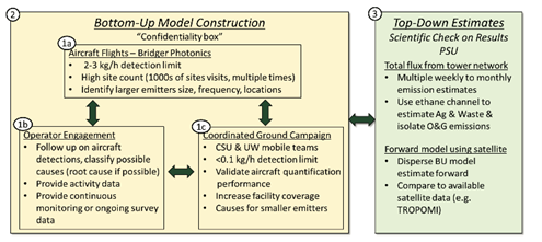
The design of this study is summarized in the graphic below:

The yellow box focuses on updating the BU inventory with Bridger Photonics flights (1a) over the DJ basin in three intensive campaigns in 2024 (spring, summer, and fall). Given Bridger’s relatively low detection limit, it can be used to understand mid-to-large emitters for BU estimates. We will also run on-site measurements (1c) using tracer-release methods (CSU, UW). Operator engagement and activity data from facilities (1b) will help the study team understand causes and sources of detected plumes. All data will help improve the study team’s BU model (MEET) that supports temporally and spatially resolved inventory estimates. Independently, PSU will run tower networks (3) that can separate O&G emissions from other sources through ethane channels to form the TD estimate.
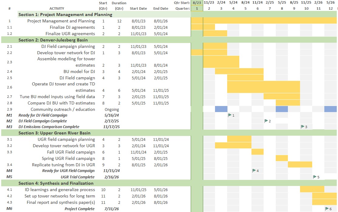
The DJ basin aircraft campaign is anticipated to take place over spring, summer, and fall of 2024, requiring project planning with the study team and participating operators in late 2023/early 2024 (anticipated around November and December of 2023). The UGR basin aircraft campaign will be staggered to allow for lessons learned from the DJ work and is anticipated to run in fall of 2024 and spring of 2025. Project planning with the study team and operators for UGR is anticipated to take place spring and summer of 2025.
Schedule:

Results:
TBD
Opportunities to Participate:
Interested in participating? Contact [email protected] for further information.
Funding Provided by:
National Energy Technology Laboratory – Department of Energy
Collaborators:
Center for Air Quality (CAQ) at the University of Wyoming
Earth-Atmosphere Interactions Lab at The Pennsylvania State University
